Rendered at 11:59:36 01/04/25
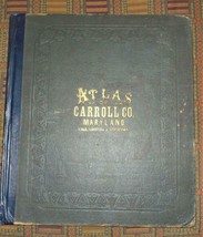
XRARE 1877 An Illustrated Atlas of Carroll County Maryland hand-colored maps
Shipping options
Offer policy
OBO - Seller accepts offers on this item.
Details
Return policy
Purchase protection
Payment options
PayPal accepted
PayPal Credit accepted
Venmo accepted
PayPal, MasterCard, Visa, Discover, and American Express accepted
Maestro accepted
Amazon Pay accepted
Shipping options
Offer policy
OBO - Seller accepts offers on this item.
Details
Return policy
Purchase protection
Payment options
PayPal accepted
PayPal Credit accepted
Venmo accepted
PayPal, MasterCard, Visa, Discover, and American Express accepted
Maestro accepted
Amazon Pay accepted
Item traits
| Category: | |
|---|---|
| Quantity Available: |
Only one in stock, order soon |
| Condition: |
Used |
| Binding: |
Leather |
| ISBN: |
Does not apply |
| Year Printed: |
1877 |
| Country/Region of Manufacture: |
United States |
| Region: |
North America |
| Language: |
English |
| Original/Facsimile: |
Original |
| Place of Publication: |
Philadelphia |
| Subject: |
Reference |
| Topic: |
Atlas |
| Publisher: |
Lake, Griffing & Stevenson |
| Special Attributes: |
Maps, 1st Edition, Illustrated |
| Seller Notes: |
Listing details
| Seller policies: | |
|---|---|
| Shipping discount: |
Shipping weights of all items added together for savings. |
| Price discount: |
5% off w/ $75.00 spent |
| Posted for sale: |
More than a week ago |
| Item number: |
1088289025 |
Item description
Added to your wish list!

- XRARE 1877 An Illustrated Atlas of Carroll County Maryland hand-colored maps
- 1 in stock
- Price negotiable
- Handling time 2 days. Estimated delivery: Thu, Jan 16th
Get an item reminder
We'll email you a link to your item now and follow up with a single reminder (if you'd like one). That's it! No spam, no hassle.
Already have an account?
Log in and add this item to your wish list.


